Ground Penetrating Radar ( GPR Testing )

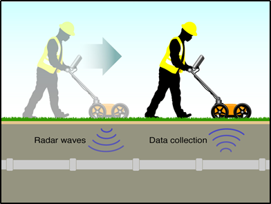
Ground penetrating radar (GPR) operates by transmitting electromagnetic waves (in the range of 10 ~ 1000 Hz) into the probed material and receiving the reflected pulses as they encounter discontinuities. The discontinuity could be a boundary or interface between materials with different dielectrics or it could be a subsurface object such as a debond or delamination (see Fig. 7.3). The amplitudes of the received echoes and the corresponding arrival times can then be used to determine the nature and location of the discontinuity.
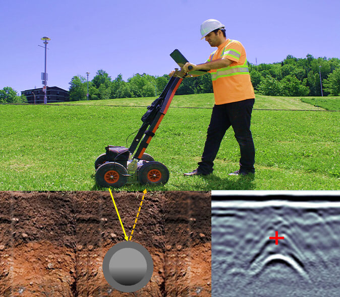
Ground penetrating radar (GPR) is a geophysical locating method that uses radio waves to capture images below the surface of the ground in a minimally invasive way. The huge advantage of GPR is that it allows crews to pinpoint the location of underground utilities without disturbing the ground.
How Does GPR Work?
GPR uses energy waves in the microwave band, ranging in frequency from 1 to 1000 MHz. GPR requires two main pieces of equipment – a transmitter and a receiving antenna. The transmitter sends electromagnetic energy into the soil and other material.
Ground Penetrating Radar works by emitting a pulse into the ground and recording the echoes that result from subsurface objects. GPR imaging devices also detect variation in the composition of the ground material.
If the electromagnetic impulse hits an object, the density of the object reflects, refracts, and scatters the signal. The receiver detects the returning signals and records variations within them. The GPR system has software that translates these signals into images of the objects in the subsurface. This is how it is used to map structures and utilities buried in the ground or in man-made structures.
What Does GPR Detect?
Ground Penetrating Radar signals can be used to find a wide range of items. This this subsurface tool is most effective when there is a large difference between the electromagnetic property of the target and surrounding material. GPR is often used to map items made of the following materials:
- Metal,
- Plastic,
- PVC,
- Concrete,
- Natural materials,
The possible applications are virtually endless. GPR is frequently utilized to detect:
- Underground utility lines and pipes
- Changes in ground strata,
- Geological features and rock obstructions,
- Air pockets or voids,
- Excavated and back-filled areas,
- Groundwater tables,
- Bedrock.
Utility Mapping Applications
Subsurface utility mapping takes advantage of GPR technology to increase the precision of their work when combined with traditional locating methods. GPR provides assistance for discovering unmarked utilities and structures, subsurface mapping, and excavating projects.
For these types of applications, the advantages are significant.
Advantages Of Ground Penetrating Radar
GPR is an extremely cost-effective and non-invasive way of surveying. It provides invaluable information before workers even break ground or start excavating.
- GPR is safe for use in public spaces and a wide variety of project sites.
- It detects metal and non-metal objects, as well as voids and underground irregularities.
- It makes it possible to measure the dimensions, depth and thickness of targets.
- Data is provided quickly and can cover a large site area.
- Only one side of the surface needs to be scanned to provide data.
- Frequencies can be regulated to deliver a range of resolution and penetration depths.
- Data collected during the survey can be seen immediately or used in later projects.
- No digging, excavating, or ground disturbance is necessary.
- Landscaping, structures, lawns, etc. are be left undisturbed by the survey process.
- It’s less expensive than other methods.
Where Can GPR Be Utilized?
As with all types of radar imaging, GPR delivers varying levels of accuracy depending on the conditions.
Soil Properties & Ground Material
GPR works by sending a tiny pulse of energy into the ground then recording the strength of reflected signals and time it takes them to return to the receiver. A scan consists of a series of pulses over a single area. While some of the GPR energy pulse reflects back to the receiving antenna, some energy continues to travel through the material until it dissipates, or the scanning session simply ends. The rate of signal dissipation varies widely, depending on the properties of the materials.
GPR is applied to a variety of ground materials, including:

- Soil,
- Rock,
- Ice,
- Fresh water,
- Pavement,
- Concrete structures.
As the energy pulse enters a material with different dielectric permittivity or other electrical conduction properties, it produces a reflection. The strength, or amplitude, of the signal is the result of the contrast in the dielectric constants and conductivities between the two materials. A pulse moving from wet sand to dry sand will produce a very strong reflection, for example, in comparison to the relatively weak reflection produced by moving from dry sand to limestone.
Depth
The ground itself can limit how deep GPR signals penetrate up to 100 feet (30 meters) deep. The ground has electrical resistivity, which means it opposes the flow of electric current to some degree. As the signal penetrates deeper, it naturally gets less effective. This depends mostly on the type of soil or rock being surveyed and the frequency of the antenna used. For example, the maximum penetration depth in concrete is usually about 2 feet. In moist clays and other high conductivity materials, GPR signals depth is significantly shallower, reaching about 3 feet (1 meter) or less.
Water Content
Dielectric permittivity of the substrate is also a factor. Dielectric permittivity is the ease with which materials become polarized. The quantity of water present in the material greatly affects dielectric permittivity. Certain materials can become polarized in the presence of an electric field.
What is the Difference Between GPR & Seismic Reflection?
The principles of GPR are similar to those of seismology. The main difference is that ground-penetrating radar uses electromagnetic energy, rather than acoustic energy of seismic waves, to detecting subsurface structures.
Seismology refraction surveys record signals that bend within the ground and arrive back at the surface. Increasing seismic velocity in the ground, related to the ground’s elastic properties and density, bends these acoustic signals back towards the surface. Seismic imaging is popular for mapping horizontal structures beneath the ground, but not very effective for characterizing vertical features.
GPR uses electromagnetic energy in the form of high-frequency radio waves, which effectively detect changes in electrical properties below the surface. Seismic energy, on the other hand, detects changes in subsurface mechanical properties.
